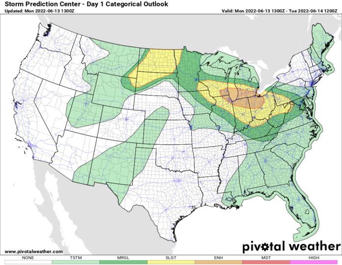
I was going to put today as DAY 1 of the heatwave. But Greenville got to 92 F yesterday. A lot of the nation got into the 90s and 100s. So I’m calling yesterday as Day 1. Today is Day 2. This is the peak of the heat in Kansas, Missouri, and Oklahoma under the strengthening heat dome overhead. Temperatures are well into the 100s under the dome in these states. In Kansas, it would not surprise me if someone hits 110 F this afternoon. It’s jacket weather in the Pacific NW and comfortably mild in the Northeast. So that means there is a big transition area, a BATTLE ZONE if you will. That battle zone is The Great Lakes. We’ve already had massive thunderstorms in the northern Mississippi Valley this morning and they are heading fast for the Great Lakes this afternoon and tonight. This area was a SLIGHT RISK at 7 AM. As of this 1030 AM writing, it’s now an ENHANCED RISK. Damaging straight-line winds, by far, is the biggest risk.
Welcome folks to the RING OF FIRE. We haven’t had this textbook of a heatwave and “ring of fire” set up in years. But it is here and will wreak havoc between the intense heat “under the heat dome” and the cooler unsettled weather surrounding it. When strong disturbances ride the “ring of fire” over the heat dome, this is where major clusters of thunderstorms develop. These can often turn into a mesoscale convective system or MCS. On rare occasions, a DERECHO, a long-lasting line of severe thunderstorms with winds at hurricane force (74 MPH or greater), that carries hundreds of miles, can form. Folks, the conditions for an MCS to form are almost a given. The question is whether or not it can form into a DERECHO. I’m telling you, folks, we have the ingredients in place for this. Whether it happens this afternoon/tonight, or later this week, or next week, I’m sounding the alarms now. Be on the lookout for a DERECHO to form. I have high confidence at least ONE of these massive, and killer, non-tornadic, but just as deadly high wind thunderstorms, will form and sweep through. Just a matter of when.

This afternoon and tonight’s MCS target (and possible DERECHO target): Milwaukee. Chicago. South Bend and Fort Wayne, Indiana. Kalamazoo, Grand Rapids, Lansing and Detroit, Michigan. Toledo, Lima, Columbus, and Cleveland, Ohio. Pittsburgh. Ohio and western Pennsylvania are definitely a tonight deal. Wisconsin, Illinois, Indiana, and Michigan, this afternoon and evening is your target. Stay weather aware. Have multiple ways to get warnings. Take them seriously when you get them. Especially since the National Weather Service is testing out enhanced wording for severe thunderstorm warnings, to accommodate for MCS and Derecho events. Remember, hurricane-force winds are… hurricane-force winds. Doesn’t matter if it twists or not at that speed. Just be ready if it comes at you.
I’ve spent most of the three paragraphs highlighting the severe potential, especially since many major metropolitan areas are at risk. But the bottom line is: Several states are on day 2 of what could be the worst heat wave in years. 90s and 100s are widespread across much of the Great Plains, especially from Nebraska SOUTH, the Ohio Valley, Tennessee Valley, and most of the Southeast US. This is going to last most of the week with a low chance of thunderstorms near and under the heat dome to cool anyone off. The worst of the heat is over Kansas and Missouri today, shifting into the Southeast tomorrow and Wednesday. Where I’m based along the I-85 corridor, multiple predictions of 100 F temperatures for Tuesday and/or Wednesday are on the board… and likely to verify. The heat gradually shifts back W to Louisiana and Texas late this week, rebuilding again Father’s Day Weekend along and west of the Mississippi, before trekking eastbound back into the Southeast early next week. We’ll see how this progresses as each day passes.
In the Pacific NW and the Northeast, hey! How y’all doing? Grab a jacket, especially in the evenings. You’re cool. And will be for a while. True mid-summer weather will get to you guys… eventually. But for now, just chill. A lot of folks in the country with 100+ temperatures wish they could be where you guys are.
And one last note: BOLO (Be on the lookout) for A TON of climate change stories in the coming days. In these types of situations, climate change will dominate the news cycle. Especially with any major damage and/or major heat records that fall. It will be touted as the worst ever, made worse by us, and all our fault. But let me give you folks something to ponder: This setup happened in 2017. It happened in 2012. It happened in 2007. It happened in 2002. It happened in 1998. It happened in 1995. It happened in 1988. It happened in 1983. It happened in 1980. Every 3 to 8 years, this type of pattern comes about in summer. Some are worse than others. Sometimes El Nino driven. Sometimes La Nina driven, like now. There is NOTHING NEW under the sun. But the legacy media is trusting you don’t remember any of these previous huge heatwaves (and damaging storms). They are going to tell you it’s your fault. The power troubles are your fault. The fact you want to be comfortable is your fault. It’s just all your fault.
Don’t believe it. Are temperatures warming overall? Yes! Dramatically? No. Is it your fault? No. Especially the way it will be portrayed. Do your best to ignore the screaming hyenas, take the precautions necessary, do your best to limit power consumption (without baking yourself), and make wise use of your resources every day just like you always do. And go live life as best as you can. That is all.

