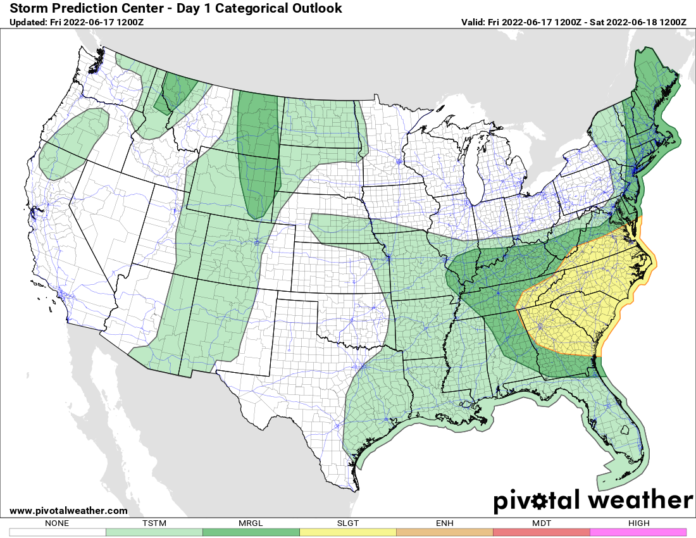
It’s still really hot and humid across most of the Mid-Atlantic and the Southeast US today. Temperatures will range from the 90s to near 100 degrees for one more day. An approaching cold front, the same one that sparked MCS development in the Great Lakes and Northeast yesterday, will settle southbound today with storms firing over the Ohio Valley, then rolling across the Appalachians into the heart of the Southeast and Mid-Atlantic this afternoon and this evening. Straight-line damaging winds are the biggest threat with these storms, the hail threat is minimal but not zero, the tornado threat is low but not zero.
Today is transition day across the aforementioned Northeast and Great Lakes with dewpoints crashing, temperatures much cooler, and the skies becoming much bluer. As this push of unseasonably cold air comes rushing in today, it will get cold enough for jackets tonight and for most of Father’s Day Weekend. This much cooler and less humid air will make its way into the Southeast, where it will still be hot, but closer to normal with noticeably lower levels of humidity.
To the west of the Mississippi, especially over the Great Plains, it’s HOT! Above normal but not record-breaking, at least for the next few days. Lots of temps 95-105 and the humidity should be a notch lower than it has been. Here the heat will build on Father’s Day then peak on Monday as the heat surges north and east. The Mississippi Valley and the western Great Lakes will see temperatures peak on Monday with some locations breaking 100 F.
Next week we are still eyeing near-record to all-time record heat invading the Southeast, Ohio Valley, and the Mid Atlantic. Particularly in the Southeast, the models, especially the Euro still pushing ALL-TIME RECORD HEAT at the Carolinas and Georgia middle of next week. It’s just a few ticks lower than yesterday but still well over 100 F and enough to where Charlotte, Greenville, Atlanta, Augusta, Columbia, Macon, and Savannah have the chance for all-time records. The watch is still on. By Monday, we’ll have a much better idea if the heat will be near record or all-time record.
Towards the end of next week, Round 2 of the heat wave spends itself and temperatures start to come down by next weekend (June 25-26). Hopefully so. It’s literally just the beginning of summer.
But this could be a very long and hot summer-like 1988. Back then there was a strong La Nina in place. That summer was epic, especially across the Great Plains, Mississippi Valley, Ohio Valley, and Great Lakes. Some of those temperature records have been locked away safely since 1988. But this year, the way things are going, I would not be surprised if we are in the midst of another 1988-like heat run. If we are, I have some thoughts on this. Saving these for later. Have a great weekend!
Today is transition day across the aforementioned Northeast and Great Lakes with dewpoints crashing, temperatures much cooler, and the skies becoming much bluer. As this push of unseasonably cold air comes rushing in today, it will get cold enough for jackets tonight and for most of Father’s Day Weekend. This much cooler and less humid air will make its way into the Southeast, where it will still be hot, but closer to normal with noticeably lower levels of humidity.
To the west of the Mississippi, especially over the Great Plains, it’s HOT! Above normal but not record-breaking, at least for the next few days. Lots of temps 95-105 and the humidity should be a notch lower than it has been. Here the heat will build on Father’s Day then peak on Monday as the heat surges north and east. The Mississippi Valley and the western Great Lakes will see temperatures peak on Monday with some locations breaking 100 F.
Next week we are still eyeing near-record to all-time record heat invading the Southeast, Ohio Valley, and the Mid Atlantic. Particularly in the Southeast, the models, especially the Euro still pushing ALL-TIME RECORD HEAT at the Carolinas and Georgia middle of next week. It’s just a few ticks lower than yesterday but still well over 100 F and enough to where Charlotte, Greenville, Atlanta, Augusta, Columbia, Macon, and Savannah have the chance for all-time records. The watch is still on. By Monday, we’ll have a much better idea if the heat will be record or all-time record.
Towards the end of next week, Round 2 of the heat wave spends itself and temperatures start to come down by next weekend (June 25-26). Hopefully so. It’s literally just the beginning of summer.
But this could be a very long and hot summer-like 1988. Back then there was a strong La Nina in place. That summer was epic, especially across the Great Plains, Mississippi Valley, Ohio Valley, and Great Lakes. Some of those temperature records have been locked away safely since 1988. But this year, the way things are going, I would not be surprised if we are in the midst of another 1988-like heat run. If we are, I have some thoughts on this. Saving these for later. Have a great weekend!

