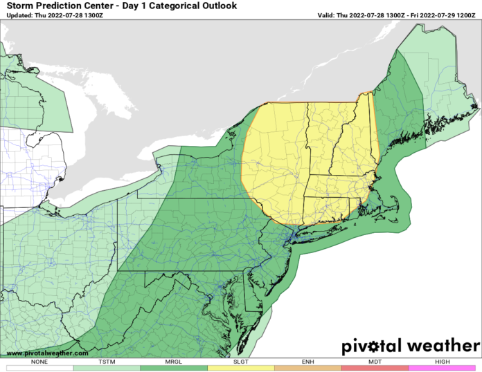
When tornado warnings get issued in Upstate NY before NOON, it’s a head snapping event. It does not happen often. I had intended to get this blog out earlier this morning but life got in the way and then a tornado warning (1045-1115 AM) went up for Wyoming and Livingston Counties in Upstate NY. Based on what I saw on the Buffalo Doppler Radar, it was a legit warning. Based off my vast experience with Upstate NY weather (and New England Weather) I’m telling you this is a day to be HEADS UP! It’s only a marginal to slight risk, but for Rochester, Syracuse, Utica, Binghamton, Albany, Poughkeepsie, Saratoga, into western and central New England from Springfield to Boston… HEADS UP! Any storms that come through this afternoon and evening have potential for anything… 60+ MPH winds. Hail. A few tornadoes. This is a day you take any watch or especially any WARNINGS from the National Weather Service seriously! Based off the storms rocking WNY as of this writing, you need to adjust plans to the east this afternoon and evening. Have a radar app, weather app, and ways to get warnings where you are at.
Across the rest of the nation, it’s comfortably cool for summer across the northern tier of the nation behind this line of severe storms coming through the Northeast. Stalled front bringing heavy rains and thunderstorms from the Virginia’s through the Ohio Valley to Kansas and Colorado. To the south of this battle zone, it’s full out dog days of summer in the Southeast and South Central US. Above normal? YES. Above normal humidity? YES! Record heat? Nope, not quite. Close for a few areas. Typical monsoon pattern in the Southwest US and a heat dome and intense heat is hitting the interior of the Pacific NW today. That heat dome will spread east across the northern tier of states next week. In the next 7-14 days, expect widespread 90s across the northern Mississippi Valley, Great Lakes and into the Northeast. There will be areas with 100+ temperatures in this zone middle to end of next week. It could be record breaking for some parts of the nation next week. Until then enjoy your relatively nice weather with less demand on the AC.
I’ll keep everyone updated on my social medias about the Upstate NY threats. If you haven’t subscribed to my social media weather feeds, here they are:
facebook.com/meterorologistrichlupia
tiktok.com/@richlupia
instagram.com/rlupia
youtube.com/meteorologistrichlupia

