
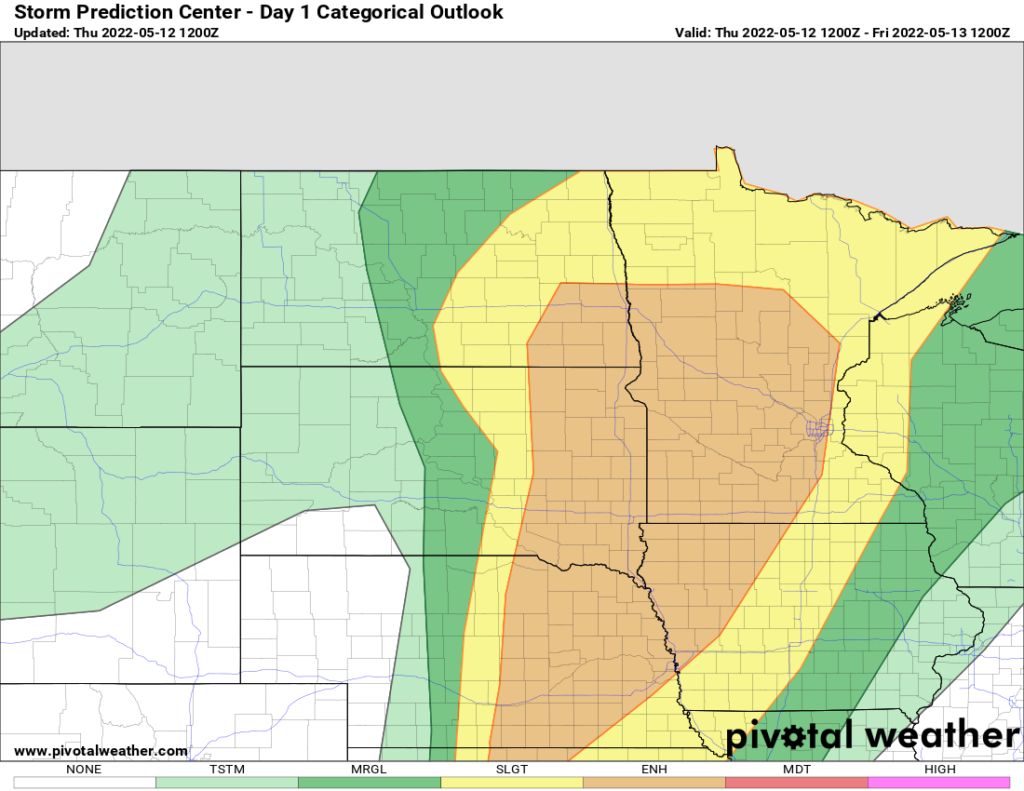
Beautiful day for much of the Eastern US. Some exceptions along the SE coast, Pacific NW, and across the northern Plains. In particular, the northern Plains and northern MS Valley is looking at a SLIGHT to ENHANCED RISK of severe thunderstorms with large hail and high winds the biggest threats. Tornadoes are the secondary threat.
Strong low pressure will move from Nebraska into South Dakota this afternoon. As it’s moving through the very warm and humid airmass with the clash of cooler and drier air behind the low, it’s a severe weather setup. It’s not an outright tornado threat. The threat is not zero, but by far, large hail 2″ or greater and high winds are the primary threat with the line of storms that does get organized this afternoon and evening. Anywhere from Minneapolis, westbound, be on the lookout. It’s going to happen over a lot of the farm country of the northern Plains and northern Mississippi Valley, without too many major metros being impacted. But if you are there, HEADS UP!
I had noted a few other exceptions to the beautiful weather: Pacific NW remains unseasonably cool with rain and higher elevation mountain snows (take whatever you can get there in this bone dry part of the nation), and the infamous “cut off” low. This is the same one that brought the severe weather last week, and ruined Mother’s Day for many on the east coast, and much further inland than we thought. It was stalled and swirling off Cape Hatteras for days. Significant beach erosion, homes destroyed, all kinds of coastal flooding, and damage in coastal NC this week. Finally, that cut-off low is weakening and moving SW towards Florida and Georgia. This means the immediate SE coast will see a higher chance for showers and thunderstorms, not just this afternoon but into Friday as well. On Friday and Saturday, the onshore flow and what’s left of that low will spread inland across the Southeast and up the Appalachians and into the Mid Atlantic and Ohio Valley yet again with one more round of rain and thunderstorms.
At first, it looked like the SE cut off and the big storm over the northern Plains would meet, merge and create a brutal cold snap and very late season snow event across the Great Lakes and interior NE. That doesn’t look like it will happen now, but there will be changes into next week. It will NOT be as warm across the northern tier of states. The southern tier of states: Yep, It’s summertime. It’s warm to hot, it’s gonna stay that way too. The dividing line next week will the near I-70 and the Ohio River Valley. Pay attention to this area for possible trouble next week. Until then, enjoy the beautiful May weather. Get out and enjoy it!
