
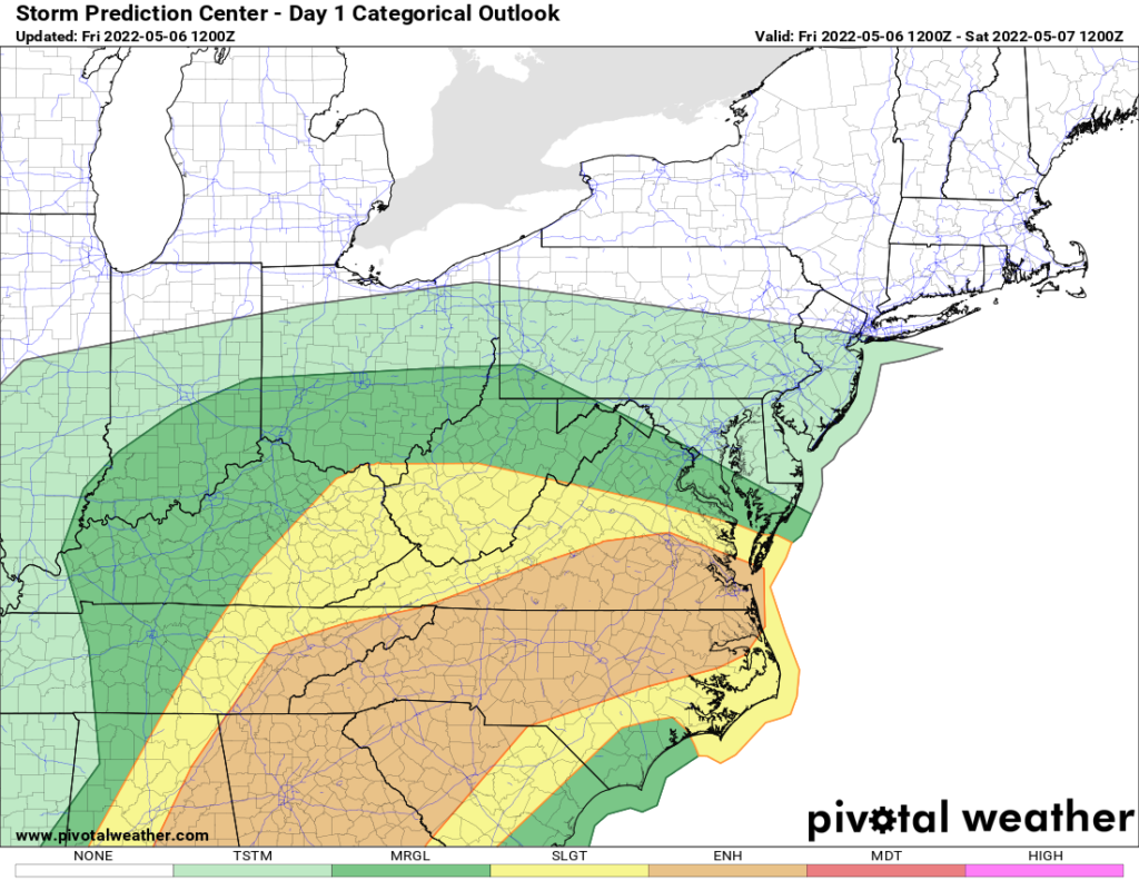
An ENHANCED RISK of severe weather exists across much of the Southeast US this afternoon and tonight. Please have multiple ways to get weather warnings. Lingering rains this weekend over the Ohio Valley, Mid Atlantic and southern New England, especially Saturday, but some will linger into Mother’s Day. Next week looks especially warm and summerlike for areas east of the Rockies!
The storm that brought severe weather the last few days from the high Plains to the Mississippi Valley is now chugging eastbound quickly. Expect storms to fire midday into the early afternoon from Montgomery, Alabama to Atlanta, Chattanooga, and Knoxville. The storms will carry during the afternoon to Macon, Georgia, the Upstate of South Carolina, and off the NC mountains into the Charlotte area. From dinnertime into the evening, the storm threat goes to Greensboro, Roanoke, Lynchburg, Raleigh/Durham, Richmond, and the Tidewater of Virginia. Damaging winds and hail are the biggest threats with these storms but the tornado chances are higher between Raleigh and RVA/Tidewater. Also in the Atlanta area. Have multiple ways to get warnings today!
This weekend it dries out over much of the eastern US with one glaring exception. This storm bringing the severe weather today, STALLS over northern VA, West Virginia, eastern Ohio, Pennsylvania, Maryland, Delaware, New Jersey, the NYC area, and Southern New England. The storm stalling means the rain will be falling. Between I-64 in Virginia and I-86 along the Southern Tier of Upstate NY, consider Saturday a WASHOUT. Rain, stiff wind, chilly. Like what happened to spring type of weather. While this does weaken some heading into Mother’s Day, the trends continue to show the clouds, rain showers, and chill, spreading INLAND from the coast. So instead of it being an NYC to Wilmington, NC thing, east of I-95, consider Mother’s Day not a good day from Boston, through most of southern New England, the whole of the NYC/Tri-State area, Philly, NJ/DE, the whole of the Delmarva, Baltimore/Washington, and most of central and eastern Virginia east of the Blue Ridge. I’m sorry, but I’d rather break the news now it will be 10-20 degrees cooler than previous projections, much cloudier, with some rain showers now.
Of course on Monday, the day after Mother’s Day, bright sunshine is everywhere! Of course! And that’s the way all next week will be. The whole Northeast, Southeast, Ohio Valley, Great Lakes, Mississippi Valley, Great Plains, all will be SUNNY AND WARM NEXT WEEK. Summerlike I dare say. You get into Mid-May and get above-normal temperatures, it’s almost a guarantee of summerlike weather. So next week, plan some time to work out in the sun, and have some time set aside especially to enjoy the outdoors. GET OUT AND ENJOY IT!
