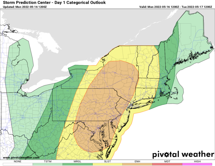
An ENHANCED RISK of severe thunderstorms with strong damaging winds the biggest threat, will exist from central and eastern NY this afternoon and evening, south into eastern Pennsylvania, New Jersey, Maryland, Delaware, and northern Virginia. Late afternoon and evening these storms will hit the NYC area and head east through western New England. The threat of hail and tornadoes is not zero, it’s still there, but this will not be a major “tornado” threat for the northeast. I’ve seen a lot worse tornado threats there and this is not one of them. Strong straight-line winds and microbursts will be the greatest danger here.
Midday and early afternoon the storms will be positioned from the Syracuse area through Binghamton towards State College PA, and into the Blue Ridge of southern PA, MD, and northern Virginia. During the afternoon between 2-5 PM, the storms roll from the Adirondacks to the Mohawk Valley, Southern Tier, into Scranton/WB PA, the Poconos, Harrisburg, Hagerstown, and into the western suburbs of DC. Between 5 PM and sunset, the Captial Region of NY, through the NYC area, Philly, Baltimore, and Washington will be in play for the severe weather. Maybe as far south as RVA. As the storms dissipate after sunset, western New England will be the place for them.
Tonight as our storm moves out, it turns much cooler across the Northeast. Tomorrow, it will not feel like spring with clouds, showers, and temperatures struggling to get past the 50s in Upstate NY, at a time of year when 70 or better is the norm. Most of New England and the Great Lakes will be in the same boat here on the temps too… below normal chill, at least for a few days.
Summertime weather has settled in across the southern US from the Carolinas through the lower Mississippi Valley, to the southern Plains, southern Rockies, and the Desert Southwest. Here 80s, and 90s with some areas breaking 100 will be common not just today but all week long. There will be threats for thunderstorms but most of these will be “air mass” thunderstorms from the heat and humidity, the “garden variety” of storms. One town gets it, the next town misses it.
It will stay cool and unsettled from the Pacific NW into the northern Rockies and the northern Plains. Not just today but through this week and into next week as well. The second half of May weather pattern is starting to lock-in. If you don’t like the weather where you are… there is June. If you like the weather where you are, you are in luck! It will stick around for a while.

