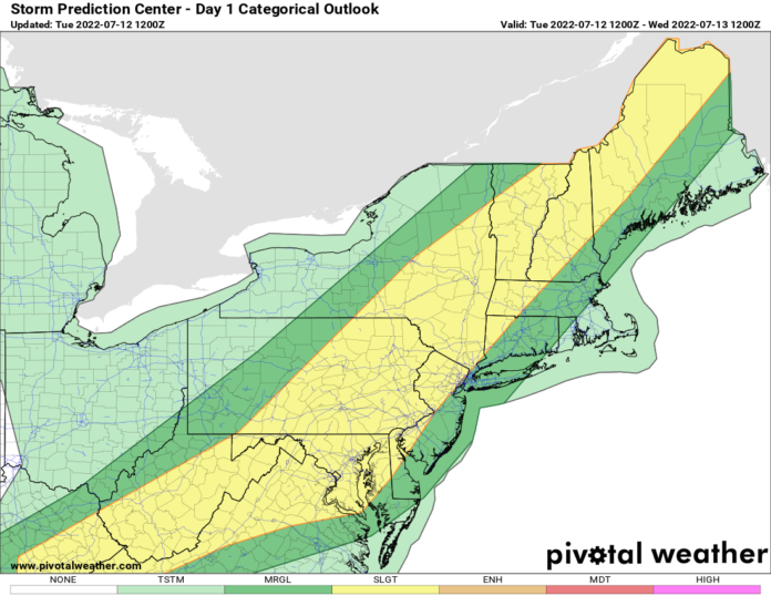
Our cold front that brought the severe weather to the Great Lakes yesterday afternoon and evening is marching towards the east. Thunderstorms are already firing up and this afternoon and evening, the threat of severe weather and straight-line damaging winds will be high. The biggest threats will be Eastern NY, Western New England, eastern PA, NJ, Maryland, Delaware, the Virginia’s, and into the Cumberland Gap. It’s a wide area under severe threat. It’s also a non-tornadic severe weather threat so more people tend to not take as seriously. Why should you take it just as seriously? Because wind is wind! It doesn’t matter if 75 MPH winds come as a weak tornado… or as a microburst or a bow echo. 75 MPH is 75 MPH. Hurricane-force winds will do damage wherever they occur. While this will be localized within storms with torrential rains and frequent cloud-to-ground lightning, a general “slight” severe weather threat should not be taken any more or less seriously that other severe weather threats. If anything, these ultimately impact MORE people than tornado threats, which are even more localized than just wind threats.
The front settles into the Carolina’s, Georgia, Alabama, and to the Gulf Coast tomorrow and sits in this same area for the next several days. It means what happened the last time a front stalled over the Carolina’s this past weekend… it’s gonna rain. A lot. And the National Hurricane Center always watches these stalled fronts once they approach the Southeast US coast and the Gulf coast because… something that is not tropical… could become tropical once it gets to that very warm (80 F+) ocean water. Low risk now but we need to keep our eyes on this closely. Regardless, the deep south from Louisiana to Mississippi, Alabama, the panhandle of Florida, and Georgia are going to be in for some major rains second half of this week.
Turning to Texas… It’s hot… yet again… Austin broke 110 F… didn’t break the thermometer but it was close! This unrelenting Texas heat wave still has a long way to go, but some good news, it won’t be near 110 today but a few degrees cooler. Shave 1-3 degrees off each day and by the weekend, highs may ONLY get into the Upper 90s across parts of Texas. That’s still above normal but in a summer like this where it’s like 1988… unrelenting for weeks to months… you celebrate ANY break you can get…
The heat dome which is from Texas to Arizona and across the southern Rockies this week will shift to the north across the Great Plains of Kansas, Nebraska, into the Dakotas and Minnesota, Iowa, and Missouri over the next several days. This weekend through next week will be much hotter in these states than what conditions are today. Be ready.
And that’s a busy July 12th in the weather department! Have a great day!
Rich

