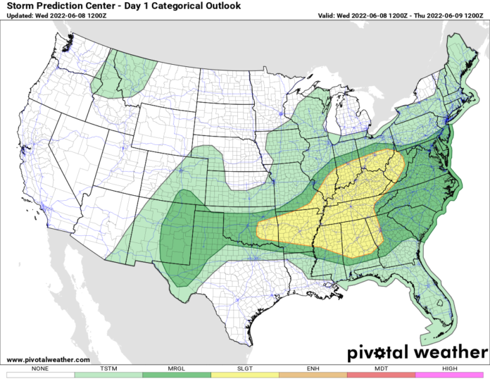
As a storm system heads to the east, there will be more than enough instability to kick off waves of thunderstorms from the western Great Lakes, through the Ohio, Mississippi, and Tennessee Valleys this afternoon and tonight. Again, like the last several days, this is not a tornado threat. The tornado threat is not zero, but it is very low. Most of the severe reports we expect will be wind damage and hail. Since these storms have lots of instability to work with and grow very high into the atmosphere, hail and downburst winds will be the biggest threats. Thankfully these severe items are more localized and not everyone sees them. But if you get hit, you get hit well. Heads up in this part of the nation and have multiple ways to get weather warnings from the NWS this afternoon and this evening.
Tomorrow what’s left of the storm moves into the Northeast US, with not as big of a severe threat, but more of a heavy rain threat and some thunderstorms. The trends for cooler air build in across the Great Lakes and push south into the Ohio Valley and Mid Atlantic behind this storm, with one more round of showers possible later Friday into early Saturday. Temperatures will be comfortable across a good part of the east, and one more break in the humidity comes to the Carolinas and the Tennessee Valley this weekend. Take particular note of this one because next week, all bets are off.
A huge dome of high pressure, a summer “heat dome” builds across the high Plains and spreads east to the Mississippi Valley by Monday, then into the Southeast including the Carolinas by Tuesday to Wednesday next week. What does this mean? Lots of the 90s and 100s for afternoon highs! This will be the first serious test of the summer as to how much power we really do have… and if we can stay cool enough during the heat next week. From the middle to the end of next week the central and southern Plains will be GROUND ZERO for this heat wave. Indications are very strong for a serious heat dome to be parked over Oklahoma and Texas with several states surrounding them in the heat as well. In this dome, 100+ degree afternoon highs will be common. A week or more out, I’m saying it’s likely. If you live in this region of the nation, get ready. It’s gonna cook next week.
Of course with lots of the 90s and 100s developing next week, and power shortages more in the news, the climate change stories I’m sure are going to start popping up like popcorn next week. Be ready for it. Expect it. But this is not 2012. This is not 1988. This is not the 1930s. It is a typically hot period we experience most summers. At this time, that’s the way it’s looking right now. As we get into this heat and the models can see better going forward, we can determine exactly how long and how hot it will get. Oh, and grab your popcorn.

