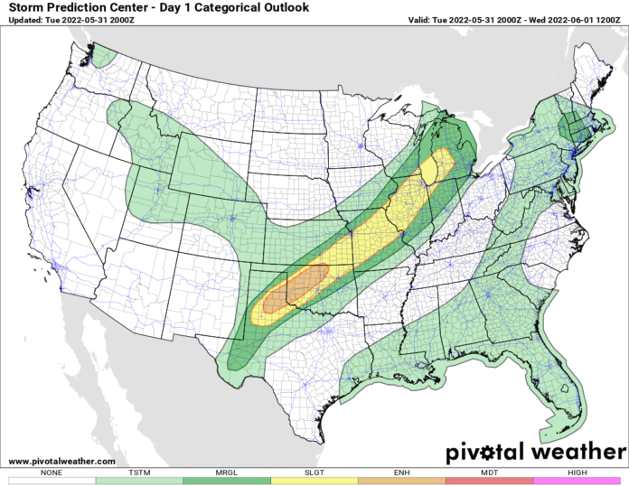
Lines of showers and thunderstorms are organized this evening from Michigan, Indiana, and Illinois, to Missouri, Kansas, Oklahoma, and Texas. Expect these lines of storms to peak late this afternoon and into the evening hours. Strong damaging wind gusts, some hail, and a few tornadoes are expected. Much of the states listed above have at least a MARGINAL risk, many areas within the marginal are SLIGHT to ENHANCED. This is part of the same storm that brought multiple severe weather warnings to the Dakotas, Nebraska, and Minnesota over the weekend.
Across the rest of the Ohio Valley, Mid Atlantic, and the Southeast, it’s summertime! Temps ranged from the mid-80s to the mid-90s. Humidity increasing. A few scattered thunderstorms mainly across Florida, the Gulf Coast, Georgia, and the Carolina coasts… but these were the daily “run of the mill” thunderstorms. No major organized severe to worry about here. Northwest remains cool and unsettled. Southwest deserts continue to bake in the heat.
Tomorrow (Wednesday) features a SLIGHT risk of severe weather from New England, through Upstate NY, Pennsylvania, and into Ohio. This is where the cold front, the line of showers and thunderstorms goes next. On Thursday, it presses south of the Ohio River into the Tennessee Valley, the Mid-Atlantic, and getting into the Virginias. A SLIGHT risk exists here on Thursday per the SPC for what it’s worth.
The end of the week is looking “interesting”. The remnants of what was Hurricane Agatha, which slammed the coast of southern Mexico yesterday, will emerge over the Yucatan Peninsula in a few days. National Hurricane Center is on this one and is assigning better than a coin flip (70% as of this blog time), a chance for development into an Atlantic tropical system. If it does develop, its name would be ALEX.
Models have been trending stronger and farther north, particularly the European model, bringing an organized tropical system into the Gulf Coast of Florida between Sarasota and Ft Myers for landfall this weekend, probably as a strong tropical storm with sustained winds in the 50-75 MPH range. Now, remember, this is several days out. Winds can go way high or way low with these storms very quickly. A big threat may peter out or sneak up on us. Tropics are always like that. If you are in the state of Florida, particularly SOUTH of I-4, HEADS UP FRIDAY, SATURDAY, and SUNDAY. The best-case scenario is a drenching rainfall in the inches category, minor flooding, and gusty winds to a tropical storm force. The worst-case scenario is a strong tropical storm or a weak hurricane hitting the southern part of the state. In either case, HEADS UP, GET YOUR PLANS READY, GET STOCKED ON FUEL, GROCERIES, and have your full emergency plan for evacuation and/or hunkering down polished, in place, and ready to go on a moment’s notice. It’s that time of year again. Hopefully, it will not be constant threat for the next six months.

