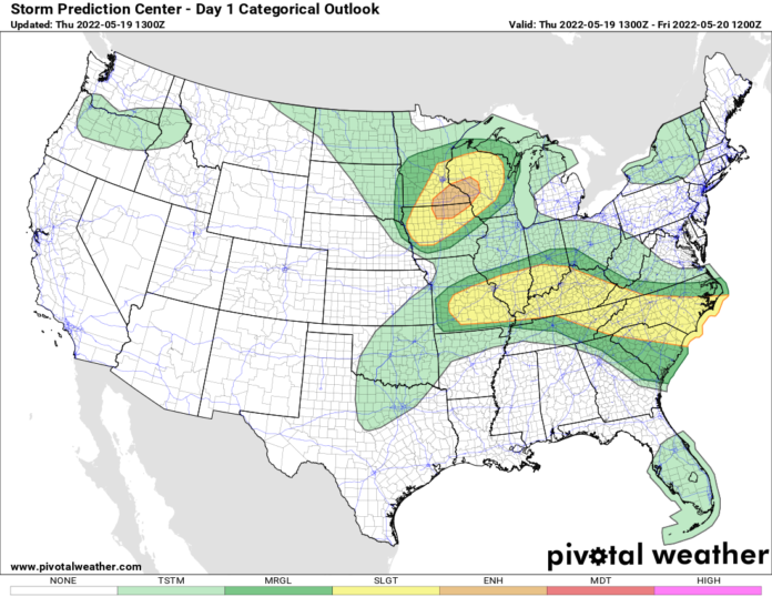
To the south, it’s in the high 80s, 90s, and lower 100s. To the north, 50s, 60s and 70s. In between this great disparity, is the battle zone. It stretches from the Carolinas through the Tennessee and Ohio Valleys back to Missouri. A separate area of ENHANCED risk of severe storms will be found across the upper Mississippi Valley between the QUAD cities and Minneapolis. Wherever these storms develop, especially if they are tacking into the hotter air like the 90s over the Carolinas, strong damaging winds and particularly intense lightning will be the hallmarks of these storms. It’s almost too warm for large hail. A tornado or two can’t be ruled out, but there is not a lot of “twist” or “directional shear” to get tornadic storms going.
So after today? Friday, especially Saturday, and Sunday will be the three hottest days so far this year. Possibly of the entire year, depending on how the rest of the summer goes. It will be well into the 90s to low 100s across the Southeast and the Ohio Valley. The big cities from DC to NYC also have an outside shot at 100, especially Saturday, but mid to upper 90s will be the rule. Even in the interior Northeast, 90-95 on Saturday is likely. Sunday is the day of transition as much cooler, more normal May weather comes blasting on in across the Great Lakes, into the Appalachians, and the Northeast. While the Storm Prediction Center has not raised flags or warned about Sunday’s severe weather potential, I’m seeing things that are getting me nervous. Anytime you have a cold front, especially in May, pushing into air that’s in the 90s, it usually does not end well. Keep your weather eye on Sunday and I’ll keep mine on it too. Fair enough?
Next week we return to closer to normal temperatures, trending a little cooler than normal across the Great Lakes and the Northeast, staying closer to normal across the Ohio Valley and Southeast. Compared to the weather over the next few days, it will actually feel cool early next week. No worries. The temps will modify and most of the nation, especially east of the Rockies, will be back closer to summertime warmth by the time we approach Memorial Day Weekend in 10 days. At least that’s how the trends are going now. So with this being a La Nina spring and summer again, more big swings in temperatures and threats of severe weather, and higher chances for hurricanes? All those play into La Nina summers. And we are in our third one in a row now. It will be interesting to see how summer plays out. I’ll be here daily following!

