Hi there! I’m your biggest heatwave in years! Nice to meet you! Let me introduce you to my friend the RING OF FIRE *cue dreadful music and loud thunder sounds*
With big heat, comes big storms and big MCS/Derechos. This heatwave has not disappointed. 84 MPH in Chicago was the 3rd highest wind speed in 150 years! Fort Wayne, Indiana set its all-time wind speed at 98 MPH! The MCS crashed through Charlotte, and Greenville then went crazy curling back around to the west over Georgia, Alabama, Florida, and Mississippi. So what’s up for today?
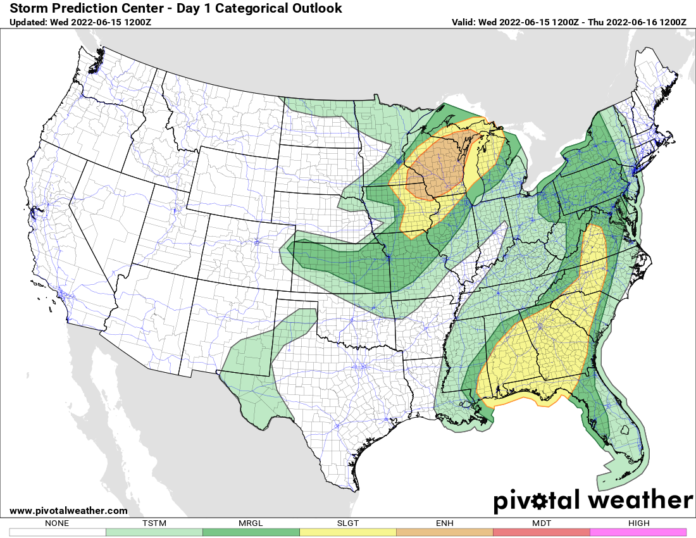
Over the northern Mississippi Valley, an MCS formed last night and is pulsing down as of this 8 AM EDT writing. Give it a few hours. By midday and this afternoon, it will blow up over Wisconsin where an ENHANCED RISK of severe weather is in place for damaging wind gusts. This MCS will cruise through the entire state of Michigan (including the UP), into southern Ontario later tonight, and approach Upstate NY tomorrow morning. Heads up!
It’s rare in Mid June to get an MCS to DEVELOP across the southern Appalachians and crash into Piedmont and lower elevations of the Southeast, curling towards the west and southwest. This is very rare territory and a very rare direction. But the models are insistent that midday/early this afternoon an MCS will blow up in the 90s to 100 F air over the western Carolinas and the southern Appalachians, then scream southwestward to westward across the Southeast. If the models were not so insistent on this happening, we in our right minds would not forecast this. But with this being hours away and strongly indicated… and the fact the models have been good with MCS development this week, we’re gonna roll with this. Charlotte, Greenville, Columbia, Augusta, HOTLANTA, Macon, Birmingham, Montgomery, Mobile, and all the way to New Orleans… you are on notice. HEADS UP FOR SEVERE WEATHER this afternoon and tonight.
So yeah, there was a heatwave, right? Yep! Under the ridge, and in areas not getting run over by an MCS, the 90s to low 100s are the rule. Much of the Ohio, Tennessee, and Mississippi Valleys have suffered under this heat this week, and it’s sticking around. Over the next few days, more thunderstorms, and more potential MCS/Derechos will plague the Great Lakes, Northeast, and Mid Atlantic through Father’s Day Weekend while the big heat builds again over the central US and the Mississippi Valley. This heat will move to the east next week. Get ready for heatwave round 2 in the Southeast, Mid Atlantic, and possibly into the Northeast next week. The Northeast next week is the biggest question mark, but from Pennsylvania southbound, it’s pretty much a guarantee.

